RapGIS · Land acquisition, compensation & resettlement

Every parcel, person, asset and shilling of a RAP, in one record.

RapGIS takes each affected parcel from identification to acquisition, and each affected person from census to restored livelihood, on a map your whole team works from.

Try the live demo Talk to us No account needed. Synthetic data.
Parcel record · demo project
LR No.
East-Embu/Mavuria/0539
Project
EMBU-DEMO-01
Area
0.95 ac
Take
0.61 ac in corridor
Owners
3 co-owners
Status
VALUED
Datum
WGS 84 · EPSG:4326

In the live demo · EMBU-DEMO-01

Parcels
1,450
Affected persons
1,449
Households
732
Assets valued
6,548
Villages
12
Roles
12

Why RapGIS

Where resettlement projects lose the thread

A Resettlement Action Plan touches among many...the surveyors, valuers, GIS officers, finance officers, lawyers, community officers, document controllers and the paying agency. Each keeps their own spreadsheet, and the gaps between them are where the failures and migraines start.

01Census & surveyParcels, persons, assets
Eligibility & valuation
Agreements
Payment
Relocation
Livelihoods restored
04GrievancesLogged and closed one by one
06
  • Surveyors
  • Valuers
  • Social
  • Legal
  • Finance
  • Managers
Each team, its own spreadsheet
A RAP run on separate spreadsheets: the six places the record breaks. Select a number for the detail.
  1. When the project establishes who and what is affected

    The failure: the project loses a dependable connection between people, places, and assets.

    Why it happens

    The parcel map, landowner register, household survey, asset inventory, and census may each be maintained separately. If their records do not align, the project can struggle to answer basic questions: Who is affected by this parcel? Which assets belong to this household? Has someone been omitted or counted twice?

  2. When verified facts become formal decisions

    The failure: a decision gets made using outdated or unverified information, and nobody can easily establish which version was used or why.

    Why it happens

    Survey data must translate into eligibility determinations, asset valuations, compensation offers, and agreements. A corrected parcel boundary or succession record may affect several downstream decisions.

  3. When commitments leave the paperwork

    The failure: the project can report what was approved without reliably showing what was actually delivered.

    Why it happens

    A signed agreement, approved compensation schedule, relocation arrangement, or livelihood-restoration plan creates obligations. Each obligation needs an owner, a deadline, evidence of completion, and a way to verify that it was fulfilled.

  4. When grievances are treated as isolated complaints

    The failure: the project resolves individual cases without learning from recurring patterns.

    Why it happens

    A complaint about ownership, valuation, succession, or delayed payment may reveal a wider data or process defect. If grievances are merely logged and closed, the underlying issue can persist across multiple affected households.

  5. When compensation is mistaken for successful resettlement

    The failure: the project measures money disbursed and households relocated, but not whether affected people have recovered their living conditions and livelihoods.

    Why it happens

    Payment is a transaction; restoration is an outcome. A household may receive compensation yet face reduced access to productive land, lost customers, longer journeys, or a diminished income. IFC guidance explicitly addresses baseline data, livelihood restoration, monitoring, and evaluation as parts of the overall process.

  6. When responsibility passes between teams

    The failure: everyone owns a task, but nobody has a complete, current view of the case from beginning to end.

    Why it happens

    Surveyors, valuers, social specialists, legal teams, finance officers, and project managers each hold part of the picture. When information moves between spreadsheets, reports, emails, and departmental systems, accountability can become fragmented.

What RapGIS holds together

Who owns what, today

Co-owners, spouses, heirs and tenants change between census and payment. RapGIS keeps ownership shares on the parcel, and succession for deceased landowners passes their exact shares to the heirs.

The cut-off date

Structures that appear after the cut-off are a common source of disputes. RapGIS compares the parcel fabric with dated satellite imagery so the evidence is on the map, not in someone's memory.

Payment without a valid record

A parcel can't move to acquisition until it has valid geometry, a verified owner and an approved compensation obligation. The database enforces this, so a shortcut in a spreadsheet can't skip it.

Proof for lenders and auditors

Grievances, consents and documents link to the parcels and persons they concern, and every change is logged. Reporting against IFC PS5 or World Bank ESS5 starts from the record, not from a rebuild.

  1. IDENTIFIEDInside the project footprint
  2. REGISTEREDNeeds valid geometry
  3. SURVEYEDAssets and persons captured
  4. VERIFIEDGeometry and owners checked; disputes branch here
  5. VALUATION READYLand and assets listed
  6. VALUEDLand in acres × KES/acre, plus assets
  7. COMPENSATIONObligation, payments, consent
  8. ACQUIREDNeeds an approved obligation
  9. CLOSEDRecord kept for audit

The parcel lifecycle in RapGIS. Steps in laterite have a gate the system checks before the parcel can move on.

What it does

One project, seen by every role

Each person signs in with a role: surveyor, valuer, compensation officer, grievance officer, resettlement officer and more. Everyone sees the same project; each role can change only its own part.

Map & parcel fabric

The project on one map

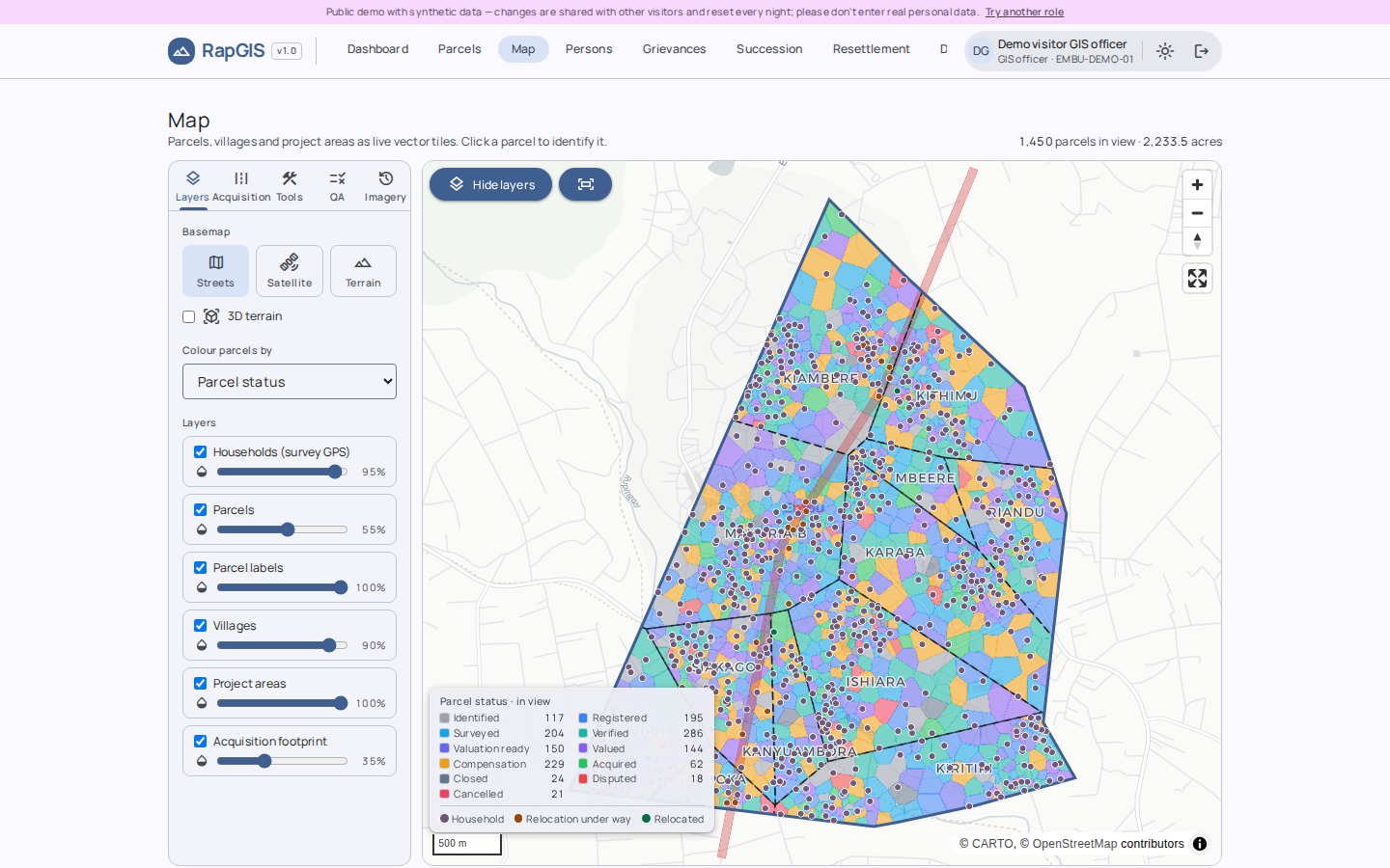
Parcels, the acquisition footprint, villages and household locations from the survey GPS, over satellite imagery.

  • Spatial checks for overlaps, gaps and slivers in the parcel fabric
  • Cut-off date check against dated imagery
  • Area within the corridor computed per parcel, in acres
Open the map as a GIS officer →
RapGIS map: parcels of the demo project with the acquisition corridor and households.
Map · EMBU-DEMO-01 (synthetic data)

Parcels, persons & ownership

A file for every parcel

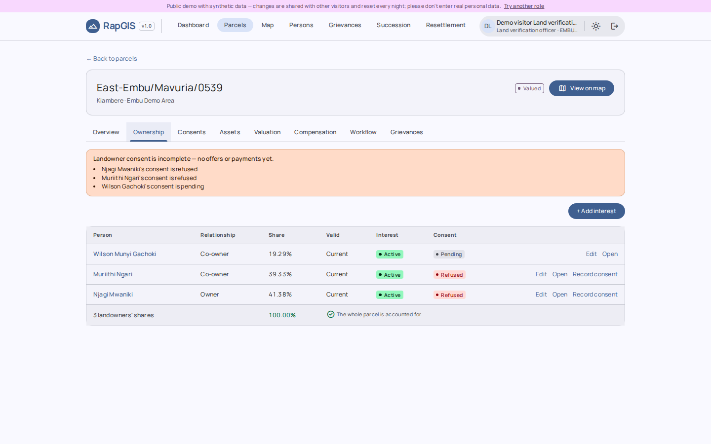
Owners and their shares, assets, valuation, compensation and payments, consents, grievances and documents, on one page per parcel.

  • Co-ownership with shares that must total the whole
  • Succession per deceased landowner's estate
  • Persons and households linked to every parcel they hold
Browse parcels as a land verification officer →
RapGIS parcel page: the three landowners, their shares and their consent.
Parcel record (synthetic data)

Progress

Where the project stands, today

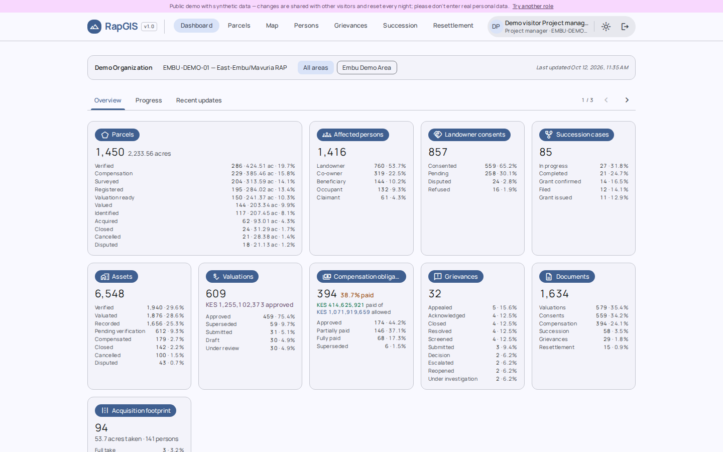
The dashboard counts parcels at each step, consents and valuations against their targets, compensation owed and paid, open grievances and succession cases.

  • Each figure opens the list of records behind it
  • Money in KES, land in acres
See the dashboard as a project manager →
RapGIS dashboard: parcel progress, compensation and grievances.
Dashboard (synthetic data)

Resettlement

From relocation to restored livelihoods

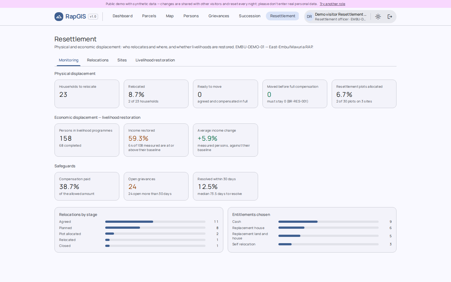
Physically displaced households, the resettlement sites they move to, and the livelihood restoration programmes that follow, with monitoring and evaluation.

  • Relocation plans per household
  • Site capacity and allocation
  • Programme enrolment and outcomes
Open resettlement as a resettlement officer →
RapGIS resettlement page: relocations, sites and livelihood programmes.
Resettlement (synthetic data)

Grievances

Registered against the complainant and the parcels concerned, tracked to resolution. Try it

Documents

A versioned document register with access by classification, up to highly confidential. Try it

Field data in

Import parcels, persons, households with GPS and grievance registers from CSV or KoboToolbox.

Succession

One case per deceased landowner's estate, with heirs, shares and the documents the court needs. Try it

Access by role

Twelve roles from surveyor to IT officer. An IT officer manages accounts; every sign-in and change is in the audit log.

Rules in the database

Business rules from the project's requirements are enforced by PostGIS constraints and triggers, and each is traced to a test.

Live demo

Try it with a project's worth of data

The demo holds a synthetic resettlement project in East Embu: 1,450 parcels with their owners, households, valuations, payments and grievances. Pick a role and you're in.

Open the demo on this page

Signs you in as a viewer. For more room, open it in its own tab.

New tab

Or start as

All names, parcels and amounts in the demo are generated. Visitors share the demo and it resets every night, so please don't enter real personal data. Uploads and imports are switched off.

How it's delivered

Your data stays on your server

Records of affected persons are sensitive: names, ID numbers, family members, payments. RapGIS is installed on a server the client controls, in their office or their own cloud account.

Field teamsKoboToolbox, CSV, survey GPS
Your server
  • PostGIS database
  • RapGIS application
  • HTTPS, accounts by role
In your office or your own cloud account. Your records stay here.
Project teamIn the browser, each on their own role
Where RapGIS runs: one server you control, reached by the field and office teams.

Install

One server, set up for you

A single Linux server runs the database, the application and HTTPS. We set it up, load your project area and parcel data, and hand over.

Train

Each role, on its own work

  • Field teams on capture and import
  • Valuers and compensation officers on their workflow
  • An IT officer on accounts and backups

Support

Updates while the project runs

Updates, fixes and help as the RAP moves from census to closure. If you'd rather not run a server, we can host an instance for you.

About

Coordexa Spatial Systems

Building better systems for land acquisition, compensation and resettlement.

Coordexa Spatial Systems develops land information systems and geospatial technology for land acquisition, compensation and resettlement in Kenya.

Founded by Elvis Mutanyi, Coordexa draws on practical experience with the information and workflows that underpin Resettlement Action Plans (RAPs). From parcel schedules and valuation records to succession documentation and grievance registers, these interconnected records are central to project implementation. Yet, when managed across disconnected spreadsheets, documents and GIS datasets, they can make coordination, traceability and informed decision-making unnecessarily difficult.

Our flagship platform, RapGIS, brings these processes into a unified, spatially enabled information management system. It is designed to connect land and affected-person records, support compensation workflows, improve information traceability and give project teams a clearer view of resettlement implementation.

Grounded in the Kenyan land administration context and informed by applicable national legislation and international frameworks, including the IFC Performance Standards and World Bank Environmental and Social Standards, our approach combines geospatial intelligence with structured data management to support more transparent, coordinated and accountable project delivery.

We work with RAP consultants, project developers and acquiring agencies seeking more reliable ways to manage land-related information and resettlement processes.

Our focus is simple: making complex land information more connected, traceable and useful for the decisions that matter.
Talk to us

For a walkthrough on your own project's data, a quote, or questions about the demo.

info@coordexaspatial.co.ke
+254 717 126 886
P.O. Box 793 – 00300
Nairobi, Kenya